

Scenery release date: 2019.03.19
The scenery is offered as a single product for FSX and Prepar3D v3 or v4.
The scenery is sold for US$ 15.00
Current Version: 1.1.2
San Jose – Juan Santamaria International airport is the primary gateway to Costa Rica, which has become one of the premier eco-tourism destinations worldwide. With access to beaches in both the Caribbean and the Pacific Ocean, it is also a popular destination for tourists seeking relaxing tropical vacations. BluePrint’s MROC scenery depicts this important airport as it exists in the spring of 2019. It is by far the most detailed and accurate scenery we have ever created. Being a medium-sized facility we were able to use transparency effects throughout the terminal which allows users to pick inside, adding an enhanced level of three-dimensional detail. We also included for the first time custom ramp and taxiway markings throughout.
Daily non-stop flights link San Jose to all major cities in Central America, the west coast of South America, Mexico, Canada and most major hubs in the southern US. As of the spring of 2019 there are two local airlines: Avianca Central America (formerly LACSA) and Volaris Costa Rica. Major foreign airlines serving MROC include Aeromexico, Air Canada, Alaska, American, Avianca, Copa, Delta, Interjet, JetBlue, Southwest, Spirit, United and WestJet. Daily flights also arrive from major cities in Europe including Frankfurt (Lufthansa), Madrid (Iberia), Paris (Air France), and Zurich (Edelweiss).
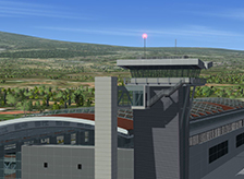
MROC boasts a modern, highly efficient international terminal featuring 13 gates with direct access to immigration and customs facilities. Our scenery includes the main terminal/concourse and the two recent concourse expansions toward the east totaling 11 gates. It also includes the ATC tower, the parking deck attached to the terminal and the fire station located west of the terminal. The latest improvements at MROC are a two-gate concourse extension toward the west and a small, entirely new domestic terminal located just west of the main terminal. These facilities opened just a few months before our scenery’s publication and we were unable to include them due to lack of information (i.e. high-quality pictures) which would enable us to create accurate 3D models. We intend to publish a free upgrade once we can complete the models.
As is characteristic of our sceneries, we positioned all 13 aircraft parking positions as accurately as possible and included realistic ramp markings and signs. Each of the 11 gates included in the scenery features a parking alignment aid, a static jetway and static service vehicles. The new domestic terminal ramp with 12 parking positions is also included. Our scenery also features most general aviation, maintenance and cargo facilities available at the airport, including the newly expanded GA ramp.
MROC has one runway with east-west orientation, which we positioned as accurately as possible in our scenery. Our scenery also features accurately laid out taxiways, including the new ones just added to facilitate movement of larger aircraft at the east end of the runway. While approaches from and departures toward the west are straightforward and aided by a complete instrument landing system (ILS), approaches from and departures toward the east are purely visual and quite challenging due to the rapidly rising terrain. In addition, windy and reduced visibility conditions are common making MROC a fun destination for pilots.
- Custom-made, optimized and fully three-dimensional Gmax models of the entire facility including:
- The International Terminal
- Accurately located aircraft parking positions around the terminal and individually customized static jetways at every gate
- Static service vehicles and parking alignment aids at every gate
- The parking adjacent to the terminals
- The ATC tower
- A significant fraction of the general aviation, aircraft maintenance and cargo facilities within the field’s boundary
- Approach lighting fixtures and navigation aid antennae for every runway
- IMPORTANT: The scenery does not include the new Domestic Terminal and the new two-gate extension at the west end of the concourse. The components will be added once we can obtain enough information (i.e. high-resolution pictures) to create accurate 3D models.
- Custom-made, high-resolution (64 pixels/meter) textures for all Gmax generated models including transparency and reflection effects
- Complimentary custom-made, high-resolution photo real ground textures depicting seasonal changes and carefully blended with the surrounding terrain
- Accurate runway and taxiway layout, including detailed markings and signs
- Realistic taxiway and ramp markings and ramp illumination effects
- Advanced, custom-made AI mapping file (AFCAD) including realistic gate/parking position layout.
NOTE: BluePrint sceneries are not compatible with FSX or Prepar3D animated service vehicles
Software Compatibility:
FSX and Windows XP, Vista, 7, 8 or 10 (All versions) or Lockheed Martin Prepar3D v3 or v4 and Windows 7, 8 or 10 (All versions). FSX and Prepar3D must be set to display the default terrain elevation mesh with 5 meters or better resolution for the scenery to display properly (1 meter resolution is recommended). Our scenery has not been tested with third-party terrain elevation mesh add-ons and the use of the scenery with such add-ons is not recommended.
- Intel Core i7 or better (Core i7-950 @ 3.07GHz fully tested)
- 4 GB RAM (fully tested)
- nVidia GeForce GTX 970 series* video processor or better (nVidia GeForce GTX 970 fully tested). Dual current-generation nVidia* or ATI video processor in SLI or Crossfire configuration may be required for best performance when dense Autogen and weather features are in use (2 X nVidia GeForce GTX 970 in SLI configuration fully tested)
Note: No significant frame-rate degradation was observed in full-screen mode when using the hardware specified above as “fully tested”.
* BluePrint Simulations sceneries are designed and tested using nVidia GPU’s exclusively. For Current generation video card specifications visit http://nVidia.com. For ATI video card specifications visit http://ati.com
Airport Information
Location:
9
° 59.63'N
84
° 12.53'W
Elevation:
3027 ft (923 m)
Runways:
07/25
9879 x 150 ft (3011 x 45 m)
Passenger Terminals:
International Terminal
Domestic Terminal
- Home
- Sceneries
- KSMF, Sacramento Intl
(New Release) - USA
- KSMF, Sacramento Intl
- KSJC, Mineta - San Jose Intl
- KLAX 2018 Los Angeles Intl v3
- KSNA, John Wayne - Orange County
- KSEA, Seattle - Tacoma Intl
- KCLT, Charlotte - Douglas Intl
- KSFO, San Francisco Intl
- KEWR, Newark Liberty Intl
- KDEN, Denver Intl
- KMSP, Minneapolis - St. Paul Intl v2
- KJFK, John F. Kennedy Intl
- KDTW, Detroit Metro
- KLAX, Los Angeles Intl v1 FS9
- KIAH, Houston Intercontinental
- KDFW, Dallas - Ft. Worth Intl
- KBOS, Boston - Logan Intl
- KMCO, Orlando Intl
- KMEM, Memphis Intl
- KIND, Indianapolis Intl
- KSDF, Louisville - Standiford Intl
- KIAD, Washington - Dulles Intl
- KDAL, Dallas - Love Field
- KRDU, Raleigh - Durham Intl
- KCLE, Cleveland - Hopkins Intl
- Canada
- South America
- Caribbean
- Europe
- KSMF, Sacramento Intl
- Buy
- Support
- Downloads
- FAQ
- Contact Us
- About Us